|
What is the
Local Plan Action Group? The Action Group is formed to oppose inclusion of
housing development on the north western edge of Penicuik, i.e. Cornbank to
Bush, as detailed in the
Edinburgh & Lothians Structure Plan 2015
Review of Midlothian & Shawfair Local Plans
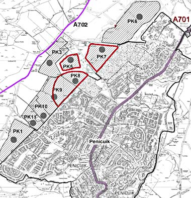
Consultation on suggested development sites
A map of the Penicuik selected sites is shown
outlined in RED
The Finalised Midlothian Local Plan and
Environmental assessment can be found on the council website at
www.midlothian.gov.uk
Other points for consideration about Sites H14
(PK8, PK5, PK7 above):
• The housing allocations for the Midlothian Local Plan are needed to
support the booming Edinburgh economy, but over 50% are being built H14,
the furthest candidate site from where they are needed
• The site will destroy part of the rural environment of the town,
creating a high altitude, exposed, car dependant community, which lacks
energy sustainability
• The site’s high elevation and proximity, will affect vista’s to and
from the Pentland Hills Regional Park, which according to section 2.1.32
of the regional plan is an “Area of Great Landscape Value”
o It will be highly visible from the most walked peaks of the Pentland
Hills Regional Park at Turnhouse Hill (by Flotterstone/Glencorse) and
Castlelaw
o Will be highly visible when viewing the hills, reaching new heights on
the Pentland Hills ridgeline
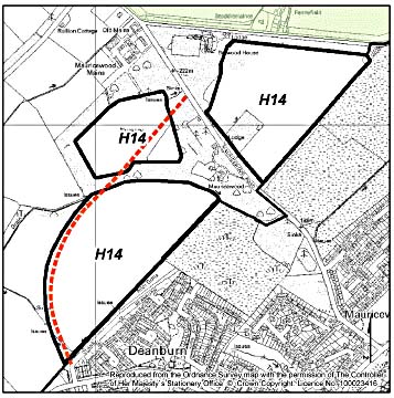
• The site impacts the setting of Listed Belwood House, and completes
the encirclement of historic Mauricewood House
• Once the current northwest boundary has been breached, the remaining
candidate sites to the northwest of Penicuik may follow (see areas
shaded with straight lines)
• The proposed 450 houses would be in addition to the already committed
development of 414 houses at Greenlaw / Deanburn (see dotted areas) and
the 151 being built by the MOD at Milton Bridge - the impact of these
has yet to be seen
• In total, there will be over 1000 new houses in front of the Pentland
Hills, between the A702 and the current northern boundary of Penicuik.
This is the size of a small town, but is being dropped haphazardly into
car dependent dormitories, with no facilities within walking distance
• The site is remote from the proposed A701 road improvements, from
public transport and from any natural re-instatement of a railway to
Penicuik
• The site is remote from the town centre, the A701 CDA transport
corridor, the High School – where the spare capacity is, the swimming
pool and library; they will be heavily car-dependent
• The site is the wrong side of Penicuik to stimulate the ailing centre
• No regular bus service operates through the sites and none are being
offered
• The required housing allocation for the A701 CDA is over subscribed by
70 houses. These extra houses should be removed from the H14 allocation
• To prevent a ribbon development, if H14 proceeds, it should not be
commence until the already committed development on the lower slopes is
completed
• Such large scale development will mean continuous building disruption
to the locality for years to come
• It will cause the coalescence of the upper Belwood rural community
The A701 multi-modal study strategy on integrating land use and
transport recommended that the northern end of the A701 corridor (around
Straiton, Loanhead and Bilston) would be more suitable for development,
yet more that 50% of the Plan’s housing for the A701 corridor is being
allocated to the southern end (at Penicuik) for the second local plan in
a row. This is an A702 development, not the required A701 and future
plans are likely to follow the precedent set.
|
Facts that will help your objection
Feel free to use these objections or your own. These must be submitted
on the Midlothian Council
objection form
by 10 August 2006
• The chosen site is at high
altitude (up to 800ft), with high-energy needs, a high carbon footprint,
effecting both natural and built heritage. This is equivalent to
building on top of Arthur’s Seat
• The council’s own environmental assessment states that the chosen site
has “significantly more negative effects on the environment than any
other site in the plan”
• The site is highly visible from the most walked peaks of Pentland
Hills Regional Park. It will be over 150ft higher up the slopes than
current housing at Deanburn, making it highly visible when viewing the
Pentland Hills ridgeline.
• The site represents a major breach of current well-defined northwest
boundary of Penicuik, setting a new precedent. With no clear boundaries,
further expansion into the Greenfield areas would be inevitable,
especially given new Midlothian housing allocations required for the
next plan.
• The site had planning rejected by the Council and on appeal by the
Scottish Executive in 2002. Nothing has changed to alter these findings,
yet the Council is now supporting the sites. The previous findings
included:
- Is car dependent given
it’s excessive distance from the Core Development Area (CDA) of the
A701
- Is likely to affect the setting of Listed Belwood House
Alternative sites:
Two alternative sites exist at Auchendinny (AH6) and Loanhead (AH4).
These sites can replace most, if not all, of the allocation at H14 and
still meet to required level of housing on the A701.
• Site AH4 at Loanhead passed all environment assessments and is urban
infill, rather than green field
• Is at the northern end of the A701 (as recommended in the multi-modal
study)
• Has a far lower carbon footprint, around 300ft lower than site H14
• Would not affect the Pentland Regional Park
• Is well served by public transport and is near to planned
infrastructure improvements, including possible rail re-instatement
• Is less exposed and has lower energy needs
• Is closest to the main employment centre of Edinburgh
• Site AH6 at Auchendinny, whilst still being towards the southern end
of the A701, is closer to Edinburgh and the Bush and is nearer to the
A701 itself
• Is at around 550ft above sea level, over two hundred feet lower than
H14
• Is less exposed, has lower energy needs
• Would not affect the Pentland Hills Regional Park
• Has an existing bus services to/from Edinburgh and to/from Penicuik
via the local comprehensives
• Is next to the proposed upgrading of the A701 (before the Milton
Bridge bottleneck)
• Would be on the natural path of any railway re-instatement.
Raise objections on Site H14 by email, or in writing to the addresses
below. Alternatively, complete the standard objection form enclosed.
Each member of a household can write in individually.
Copy of Full
Flyer Send
completed forms by email to:
local.planreview@midlothian.gov.uk, Or by post using the details
below:
Planning Unit, Finalised Local Plan,
Strategic Services,
Midlothian Council,
8 Lothian Road,
Dalkeith. EH22 3ZN.
 |